Hi just looking for advice on a good truck sat nav I am a new driver and currently looking for work so looking for a sat nav that’s simple to use and will allow me to easily put in truck dimensions I know they are not 100% but I have looked online and they seem to vary in cost so some advice from anyone would be great
Hi I would recommend tomtom 6250. It comes with lifetime maps and traffic.
Its for 389 pounds from tomtom direct
But if you put the voucher code SCOTT you will get 68 pounds off with it well worth it.
The xgody ones from ebay get recommended on here they are for HGVs and you can input truck height etc and are only £42 or so, I used it the other day and it seemed mostly good (xgody 718), combine it with google maps and it’s a cheap solution if you don’t have £350 to spend on the tomtom or garmin truck ones. Eventually when I can afford it i’ll probably get the expensive ones, but until then this seems to work well.
Look on ebay … you’ll get refurbished tom-tom 5250 with lifetime traffic and maps and warranty for 200
Sent from my SM-G981B using Tapatalk
Cheapest way to get Sat Nav would be downloading Road Lords app (free truck specific) . Combine and use it with Google Maps and it’s OK to work with until you save monies for tomtom6250.
Tomtom is expensive, but as a tool for driving with real time traffic updates is worth every penny.
Totalsatnavs Co UK is the cheapest place you could buy one. I did, and am very happy.
Sent from my LYA-L09 using Tapatalk
Tomtom 6250 all day long
Another vote for 6250, great bit of kit and easy to use.
Sent from my SM-G960F using Tapatalk
I use Garmin Dezl-700. Live traffic and everything you need
I have the Tomtom 520 professional its also good about 200 quid.
I have the 6250. It’s not a good satnav. Routing is very questionable sometimes - taking you the long way unnecessarily. I’ve saved 15mins on an hour’s drive before now by going the way I know is faster. It’s tried to put me under a low bridge, and width and weight restrictions that it doesn’t know about also. Sadly it’s still probably one of the best products out there but it leaves a lot to be desired. Don’t blindly follow it whatever you do.
SJB:
I have the 6250. It’s not a good satnav. Routing is very questionable sometimes - taking you the long way unnecessarily. I’ve saved 15mins on an hour’s drive before now by going the way I know is faster. It’s tried to put me under a low bridge, and width and weight restrictions that it doesn’t know about also. Sadly it’s still probably one of the best products out there but it leaves a lot to be desired. Don’t blindly follow it whatever you do.
This one of the reasons I went for Garmin instead
Sent from my iPhone using Tapatalk
SJB:
I have the 6250. It’s not a good satnav. Routing is very questionable sometimes - taking you the long way unnecessarily. I’ve saved 15mins on an hour’s drive before now by going the way I know is faster. It’s tried to put me under a low bridge, and width and weight restrictions that it doesn’t know about also. Sadly it’s still probably one of the best products out there but it leaves a lot to be desired. Don’t blindly follow it whatever you do.
It’ll give you three route options
Sent from my SM-G960F using Tapatalk
wrighty1:
It’ll give you three route options
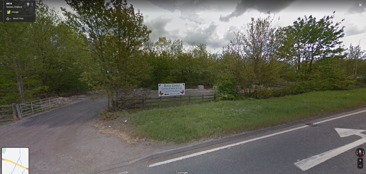
It’s taken me off the A12 and tried to put me down here today mate… that’s a private access way (and spot the locked gate). Funny thing is, I looked at the route on my break afterwards to see what the hell it was playing at, as it’s one of the worst mistakes yet… and it would be possible to go that way, if you were on horseback in the 1950’s… there IS an old track leading to my destination via the entrance in the pic. There’s also a couple of more sensible ways in that are actually suitable for motorised vehicles which I found with the assistance of Google Maps because the TomTom lost its ■■■■ again.
What bothers me about it is, it’s set to take the fastest route, but most of my deliveries are local and I know the roads… let’s say the fastest route it thinks there is, will get me there by 3pm… as soon as it tries to take me the wrong way and I ignore it and go my own way, the eta will change to 2.55pm immediately! So the thing knows my way is faster - it should have taken me there first!!!
SJB:
wrighty1:
It’ll give you three route options
It’s taken me off the A12 and tried to put me down here today mate… that’s a private access way (and spot the locked gate). Funny thing is, I looked at the route on my break afterwards to see what the hell it was playing at, as it’s one of the worst mistakes yet… and it would be possible to go that way, if you were on horseback in the 1950’s… there IS an old track leading to my destination via the entrance in the pic. There’s also a couple of more sensible ways in that are actually suitable for motorised vehicles which I found with the assistance of Google Maps because the TomTom lost its [zb] again.What bothers me about it is, it’s set to take the fastest route, but most of my deliveries are local and I know the roads… let’s say the fastest route it thinks there is, will get me there by 3pm… as soon as it tries to take me the wrong way and I ignore it and go my own way, the eta will change to 2.55pm immediately! So the thing knows my way is faster - it should have taken me there first!!!
Not sure if it’s possible for one give faulty routes but mine has been fine as was the 6000 before it. Could be worth contacting tom-tom about it.
Sent from my SM-G960F using Tapatalk
Without a doubt, sat navs are brilliant and I use one. But there’s no substitute for good map reading skills and experience.
I use sat nav for traffic warnings and maybe the last mile. But I use a map to get close to where I want to be.
Pete ![]()
![]()
Hi there when I was a new pass 3 years ago my first job was/ is driving double deck 16 foot high truck obviously there is no substitute for being aware of the road restrictions but I also wanted a satnav to give me pics of mind that I am or a good route so I bought what could afford which was a used Garmin DEZL 770D off the Bay can’t Remember the exact price but around £150.
I can’t recommend it highly enough after doing the settings to the truck I would be driving it has never sent me down a dodgy route although it is set up for the fastest route now I know my way round a bit better it doesn’t necessarily take me the quickest route.
Ok so recently I’ve been driving a nice new truck but sat nav has been having problems locating a satellite signal or dropping out of signal it’s got all the updates it’s supposed to have but it’s not helping In built up areas like central London poop poop poop
Can’t afford a new one and through recommendation I downloaded the app Copilot to an old iPhone and @ £8.99 a month I’m not complaining.
Running alongside the garmin it can take 5 - 10 mins off a route in town But a few times it’s taken me off the motorway to put me back on 6-7 miles later.
I still highly rate the garmin and the new Garmin dezlcam-lmt-d is on my Crimbo wish list
Paul@PSTT:
Without a doubt, sat navs are brilliant and I use one. But there’s no substitute for good map reading skills and experience.I use sat nav for traffic warnings and maybe the last mile. But I use a map to get close to where I want to be.
Pete

Well said. After 6 years of truck driving I have found no satnav is perfect. Most important is that with a Garmin or TomTom you will find after 3-4 years the screen goes blank. The rogues built in a ‘refurbishment’ requirement to make themselves extra cash on top of the purchase. That puts my backup along with the requirement that updates have to be done on a windows/mac computer and went over to linux in 2007.
I’ve tested most and find by far the best is Here maps - updated maps every month and its routing excellent but it is quite a basic app. Copilot is a close second as it offers way points to aid route planning but map updates are only 6 monthly if that. Important thing about updates is it is not just new roads but corrections. So far with Here maps I’ve found one fault (in 100k miles per year over 6 years) - on the A31 to Poole it takes you off the A31 at J13 and puts you back at J14 hmm. That’s nothing to complain about really! Google os ok but uses data and its routing I’ve found not so good but great on a large industrial estate to look up the exact location of a company.
As Peter says no substitute for good map reading skills - I’d call it route planning which really is an essential requirement when one is in an artic. I use both Here maps and Copilot to route plan (comparing the two if any different), sometimes jotting down the roads on my Jotter pad (or sketch to refer to) and then back to the satnav ‘to bring me in’ the last few mile.
Bridges and weight restrictions one covers with route planning. When I did use a track satnav I found I was lazy on checking routes and I found would use roads ‘not suitable for HGV’ as these are not weight restricted and thus not included. I have been to loads of nurseries and farms in remote places and I would always trust the map (Philips Truckers Navigator not the AA one as it does not cover weight restrictions) and a plain car road satnav.
Over a year now I’ve been driving an artic and I simply wouldn’t go anywhere without the map and careful route planning. e.g Slough… one goes in from the East and leaves via the East as there are 6 bridges on the West side and one will get stuck. There is added ‘artic driving joy’ with an LST trailer as one cannot spin and in my view even more important to carefully route plan. I utterly hate the LST and hope their use will fade as service stations and many destinations do not have space to accommodate them. I found standard artic nerve racking at first but one grows to love the manoeuvrability of it (best place to learn is in London and ‘you certainly pull your hair out’)… but I don’t think I will ever like the LST… the 28 pallet version is one thing - the 30 pallet is another. I was in Sutton-in-Ashfield the other week with an LST and thought of popping in for ‘break’… then second thoughts as Peter wouldn’t jump with joy at an LST turning in the yard. (LOL).
As for a satnav… there great but always use the map! Save yourself some cash. You need two anyway in case one stops working… no one mentions that. I have one phone (no SIM card) as a satnav and then another used as a phone (as backup).
jessejazza:
Paul@PSTT:
Without a doubt, sat navs are brilliant and I use one. But there’s no substitute for good map reading skills and experience.I use sat nav for traffic warnings and maybe the last mile. But I use a map to get close to where I want to be.
Pete [emoji38] [emoji38]
Well said. After 6 years of truck driving I have found no satnav is perfect. Most important is that with a Garmin or TomTom you will find after 3-4 years the screen goes blank. The rogues built in a ‘refurbishment’ requirement to make themselves extra cash on top of the purchase. That puts my backup along with the requirement that updates have to be done on a windows/mac computer and went over to linux in 2007.
I’ve tested most and find by far the best is Here maps - updated maps every month and its routing excellent but it is quite a basic app. Copilot is a close second as it offers way points to aid route planning but map updates are only 6 monthly if that. Important thing about updates is it is not just new roads but corrections. So far with Here maps I’ve found one fault (in 100k miles per year over 6 years) - on the A31 to Poole it takes you off the A31 at J13 and puts you back at J14 hmm. That’s nothing to complain about really! Google os ok but uses data and its routing I’ve found not so good but great on a large industrial estate to look up the exact location of a company.
As Peter says no substitute for good map reading skills - I’d call it route planning which really is an essential requirement when one is in an artic. I use both Here maps and Copilot to route plan (comparing the two if any different), sometimes jotting down the roads on my Jotter pad (or sketch to refer to) and then back to the satnav ‘to bring me in’ the last few mile.
Bridges and weight restrictions one covers with route planning. When I did use a track satnav I found I was lazy on checking routes and I found would use roads ‘not suitable for HGV’ as these are not weight restricted and thus not included. I have been to loads of nurseries and farms in remote places and I would always trust the map (Philips Truckers Navigator not the AA one as it does not cover weight restrictions) and a plain car road satnav.
Over a year now I’ve been driving an artic and I simply wouldn’t go anywhere without the map and careful route planning. e.g Slough… one goes in from the East and leaves via the East as there are 6 bridges on the West side and one will get stuck. There is added ‘artic driving joy’ with an LST trailer as one cannot spin and in my view even more important to carefully route plan. I utterly hate the LST and hope their use will fade as service stations and many destinations do not have space to accommodate them. I found standard artic nerve racking at first but one grows to love the manoeuvrability of it (best place to learn is in London and ‘you certainly pull your hair out’)… but I don’t think I will ever like the LST… the 28 pallet version is one thing - the 30 pallet is another. I was in Sutton-in-Ashfield the other week with an LST and thought of popping in for ‘break’… then second thoughts as Peter wouldn’t jump with joy at an LST turning in the yard. (LOL).
As for a satnav… there great but always use the map! Save yourself some cash. You need two anyway in case one stops working… no one mentions that. I have one phone (no SIM card) as a satnav and then another used as a phone (as backup).
Sorry but most of that is rubbish, sat navs do not crash after 3-4 years and used in conjunction with Google maps they are an excellent bit of kit. I have the Phillips truck atlas and it’s been under my bunk for the last 4 years, you will find with all the road building/updating going on these quickly become out of date. As for updating sat navs the new Tomtom updates via WiFi. I drive all over Britain and have honestly never needed to use a map, set up properly sat navs are more than adequate as long as a bit of common sense is used.
Modern technology is a wonderful thing and can make the job easier, some people still seem averse to it [emoji849]
Sent from my SM-G960F using Tapatalk
jessejazza:
Most important is that with a Garmin or TomTom you will find after 3-4 years the screen goes blank. The rogues built in a ‘refurbishment’ requirement to make themselves extra cash on top of the purchase. That puts my backup along with the requirement that updates have to be done on a windows/mac computer and went over to linux in 2007.
The current Tomtom “Pro” models update via WiFi, with no need to connect via a PC or Mac (although you can still do so if you wish).
One of the main issues with paper maps is that they are never up to date (even if you buy a new one every year). Also the Phillips Trucker Atlas is dire for use in that there Lunnon, as it shows only a few of the height restrictions, and virtually none of the numerous weight, width and length restrictions.
Sent from my VOG-L09 using Tapatalk
wrighty1:
jessejazza:
Paul@PSTT:
Without a doubt, sat navs are brilliant and I use one. But there’s no substitute for good map reading skills and experience.I use sat nav for traffic warnings and maybe the last mile. But I use a map to get close to where I want to be.
Pete [emoji38] [emoji38]
Well said. After 6 years of truck driving I have found no satnav is perfect. Most important is that with a Garmin or TomTom you will find after 3-4 years the screen goes blank. The rogues built in a ‘refurbishment’ requirement to make themselves extra cash on top of the purchase. That puts my backup along with the requirement that updates have to be done on a windows/mac computer and went over to linux in 2007.
I’ve tested most and find by far the best is Here maps - updated maps every month and its routing excellent but it is quite a basic app. Copilot is a close second as it offers way points to aid route planning but map updates are only 6 monthly if that. Important thing about updates is it is not just new roads but corrections. So far with Here maps I’ve found one fault (in 100k miles per year over 6 years) - on the A31 to Poole it takes you off the A31 at J13 and puts you back at J14 hmm. That’s nothing to complain about really! Google os ok but uses data and its routing I’ve found not so good but great on a large industrial estate to look up the exact location of a company.
As Peter says no substitute for good map reading skills - I’d call it route planning which really is an essential requirement when one is in an artic. I use both Here maps and Copilot to route plan (comparing the two if any different), sometimes jotting down the roads on my Jotter pad (or sketch to refer to) and then back to the satnav ‘to bring me in’ the last few mile.
Bridges and weight restrictions one covers with route planning. When I did use a track satnav I found I was lazy on checking routes and I found would use roads ‘not suitable for HGV’ as these are not weight restricted and thus not included. I have been to loads of nurseries and farms in remote places and I would always trust the map (Philips Truckers Navigator not the AA one as it does not cover weight restrictions) and a plain car road satnav.
Over a year now I’ve been driving an artic and I simply wouldn’t go anywhere without the map and careful route planning. e.g Slough… one goes in from the East and leaves via the East as there are 6 bridges on the West side and one will get stuck. There is added ‘artic driving joy’ with an LST trailer as one cannot spin and in my view even more important to carefully route plan. I utterly hate the LST and hope their use will fade as service stations and many destinations do not have space to accommodate them. I found standard artic nerve racking at first but one grows to love the manoeuvrability of it (best place to learn is in London and ‘you certainly pull your hair out’)… but I don’t think I will ever like the LST… the 28 pallet version is one thing - the 30 pallet is another. I was in Sutton-in-Ashfield the other week with an LST and thought of popping in for ‘break’… then second thoughts as Peter wouldn’t jump with joy at an LST turning in the yard. (LOL).
As for a satnav… there great but always use the map! Save yourself some cash. You need two anyway in case one stops working… no one mentions that. I have one phone (no SIM card) as a satnav and then another used as a phone (as backup).
Sorry but most of that is rubbish, sat navs do not crash after 3-4 years and used in conjunction with Google maps they are an excellent bit of kit. I have the Phillips truck atlas and it’s been under my bunk for the last 4 years, you will find with all the road building/updating going on these quickly become out of date. As for updating sat navs the new Tomtom updates via WiFi. I drive all over Britain and have honestly never needed to use a map, set up properly sat navs are more than adequate as long as a bit of common sense is used.
Modern technology is a wonderful thing and can make the job easier, some people still seem averse to it [emoji849]Sent from my SM-G960F using Tapatalk
Yours hasn’t yet (I take it) but will do. TomTom maps are hopelessly out of date. As for common sense that’s a personal thing. I’m not wasting £400 quid.