the website below was being plugged in the letters page of Truckstop news someone may find it useful
cambridgeshire.gov.uk/transp … ging/heavy
now this is what all councils should be doing
the website below was being plugged in the letters page of Truckstop news someone may find it useful
cambridgeshire.gov.uk/transp … ging/heavy
now this is what all councils should be doing
Hitch thanks for posting this site
it is as you stateda good site
which is full of usefull Infomation
which has to do with our day to day work
ta mate. worth getting put in the usefull
links post i do belive,
Would be fantastic if they managed to get some siple facts right ![]()
On the bridge heights page - .
cambridgeshire.gov.uk/transp … limits.htm
the first two are Guyhirn & Stonea, both of which are within 5 miles of me.
Guyhirn has NO railway bridge, the only one I can think of was on the A141 at Rings end, which was demolished years ago ![]()
Stonea (as per Ely) IS a low bridge but irrelevant because theres a manned gated cross over beside it ![]()
Incompetent Fools ![]()
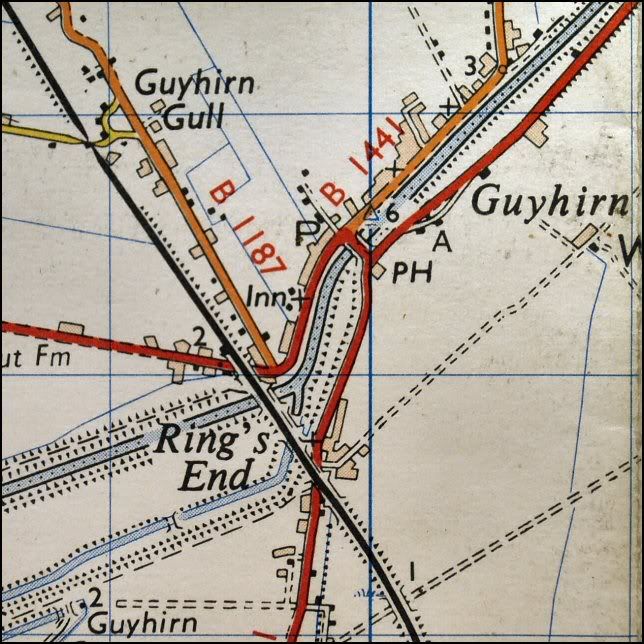
Guyhirn once had two railway bridges over roads; one over the A141 - as Scab mentioned, and the other over the A47. The piers of the rail bridge that crossed the River Nene can still be seen, this bridge was between the the two road-rail bridges.
All these bridges went years ago.
The Cambs. website is a good idea, but spoiled if it’s going to contain inaccurate information.
stop moaning about it and let them know then. ![]()
pity theres still the anti lorry brigade though
OK, taking into account the errors pointed out by other memebers with local knowledge, surely, this effort should be praised by the Haulage industry and drivers.
To me, this is the sort of information we desperately need, to be able to do our job more easily, and without upsetting the indiginous population.
This initiative should be followed by ALL county councils.
Well done Cambridgeshire County Council, and thanks for the info.
stop moaning about it and let them know then
I have done so ![]()
IDIOTS Why is it that 2 ex drivers know the real facts & these muppets with good jobs are such a shower ![]()
I do remember the rings end bridge on the A141 Sheeter, but I think the A47 one must’v been demolished befoare my time, not sure though. Did it go years before the old road bridge was binned ?
Scab, this is for you, and anyone else who is familiar with the A47/A141 junction at Guyhirn. It’s from a 1974 Ordnance Survey map and clearly shows the bridge(s) in question. The old GN/GE railway has been closed for some years now, I can’t remember the exact year that each of these bridges disappeared but it was long enough ago, to prompt me to send an email off to Cambs. C.C., before I posted anything here.
The road layout has changed considerably at Guyhirn since the 1970’s, that layby loop, coming south from Wisbech, had an great grub stall in it, and it was very well used by lorry drivers.
look no one is all ways perfect,and so they have made a mistake
send them a e-mail and tell them,this is also what the highways guide
said when they put their first booklet on truckstops out,
AT least they are doing some thing unlike many others,
I know some drivers from abroad who say thanks
as the site is a help for them,
it’s quite funny but about 18 months back i saw a job advertised for road transport routes liason officer or some similar title in our local paper (hunts post) so looked it up on the Cambridgeshire County Council website - no transport experience necessary just a degree ![]() this is obviously what the successful applicant did with their first 35k plus perks year then
this is obviously what the successful applicant did with their first 35k plus perks year then ![]()
I remember it all, except the bridge being there Sheeter, but in '72 i was only 11, so if it was pulled down soon after that, it would have escaped my failing old memory ![]()
Am i right in thinking that John Tomas’s yard (now Play2Day / bowling) was once a station ■■ I’m nealry 100% sure it’s called the Station yard, and from your map it’s positioned perfectly ?
This email has just come in, from Cambridgeshire County Council;
Dear Mr #######,
Thank you for your email regarding the lack of a bridge at Guyhirn.
This has been amended but may take some time before the amendment shows
on the site [due to staff changes etc].
Scab, the station was on the left of the A141, between the current Chinese Resturant and the old Methodist Chapel at Ring’s End.
The line closed in 1982, so obviously the A47 bridge went sometime after that, I can’t remember - I was living in Hertfordshire then. I think the A141 bridge went quite quickly after the railway closure because it was restricted in height.
Am i right in thinking that John Tomas’s yard (now Play2Day / bowling) was once a station ■■
No, it wasn’t the station, it was the station Goods Yard, if you want more detailed info I can supply it, but not on this Thread.
but in '72 i was only 11
Before you took the 11-Plus exam, I used to come up from Hertfordshire, driving old Leyland Comets, AEC Mandators or a Mercury rigid bringing metal cans or cardboard cartons to the food canning places in Wisbech.
Scab, the station was on the left of the A141, between the current Chinese Resturant and the old Methodist Chapel at Ring’s End.
Tiny little station then !! From memory, there is only a driveway between the chinese & the little round house, then the remains of the brideg & almost immediately after it is a house & then the chapel. Was it the house (which i believe Mr. Steele used to own ■■)
Before you took the 11-Plus exam, I used to come up from Hertfordshire, driving old Leyland Comets, AEC Mandators or a Mercury rigid bringing metal cans or cardboard cartons to the food canning places in Wisbech.
Presumably you are now retired ? Don’t you ever wonder what the latest tackle is like, i do. I have been away from it full time for the past 10 years & it’s moved on a long way. Of course i still have a few good mates from my driving days, so hear all the gossip about these new fangled machines ![]()
![]()
![]()